Windy conditions, severe weather potential
Published 9:38 pm Wednesday, April 10, 2024
|
Getting your Trinity Audio player ready...
|
Our office is currently monitoring an approaching weather system that will bring windy conditions, rain, and the potential for strong storms to our area tomorrow. Forecast details for Beaufort County include:
Rain
- Rain chances will increase after noon tomorrow with widespread showers likely by 2pm. Periods of widespread showers are expected to continue through midnight, with most areas receiving ¾ to 1 inch of rain.
- Our heaviest rains are forecasted to occur between 2pm and 8pm tomorrow.
Strong to Severe Storms
- Isolated strong to severe storm are possible with this passing system tomorrow afternoon.
- Our greatest chance of experiencing strong to severe storms will be between 5pm and 10pm tomorrow afternoon.
Wind
- Thursday
- South winds are expected to increase quickly after sunrise, becoming sustained between 15 and 25 mph, with frequent gust of 30 to 35mph.
- Friday
- Winds will transition to the west on Friday, remaining sustained between 15 and 20 mph with gust of 20 to 25 mph through sunset.
- Saturday
- SW winds will increase after sunrise, becoming sustained between 15 and 20 mph, with gust of 20 to 25 mph expected through 5pm.
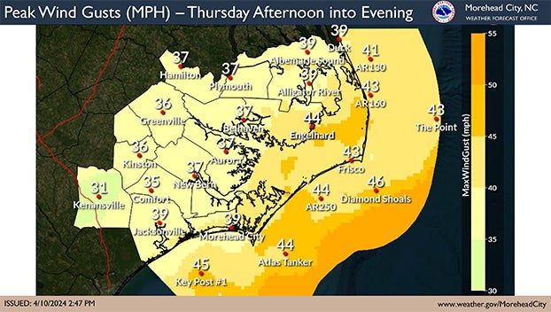
Please see below and attached briefing from the National Weather Service for more information.
From the National Weather Service, Morehead City:
A strong frontal system will impact eastern NC Thursday into Friday, bringing the potential for several hazards – widespread showers with isolated strong storms, gusty winds, and coastal impacts.
Changes since the last briefing –
- Peak wind gusts have been increased for all of Eastern NC (35 to 45 mph)
- Gale Watches have been upgraded to Warnings and expanded to all sounds and large inland rivers.
Please see the attached briefing for details.
NWS Morehead City Briefing #3 – April 11-12, 2024
More Weather


SportsPlus
How to Watch the MLB Baseball Playoffs on Sunday, Oct. 6: TV Channel, Live Streaming, Start Times
The San Diego Padres and the Los Angeles Dodgers take the field for one of many exciting matchups…
How to live stream NFL RedZone Week 5 with a free Fubo trial
Football fans, want to watch all of the NFL action this week? Forget flipping back and forth between…
MLB Playoff Betting Lines and Picks Today | Oct. 6
The San Diego Padres and the Los Angeles Dodgers hit the field in one of many exciting matchups…
How to Watch the WNBA Playoffs Today | Oct. 6
On a Sunday WNBA playoff slate that features two exciting matchups, the New York Liberty versus the Las…
WNBA Betting Picks: Sunday, Oct. 6
Wondering how you should bet on today’s WNBA games? Look no further. Below you’ll find computer predictions on…
-
Polls
 Loading ...
-
-