Severe weather potential today-Thursday
Published 2:25 pm Tuesday, May 7, 2024
|
Getting your Trinity Audio player ready...
|
From Chris Newkirk, Beaufort County Emergency Services:
Our office is currently monitoring an increasing risk of severe afternoon thunderstorms over the next three (3) days. Our greatest chance of experiencing these stronger storms is currently forecasted to occur between 2pm and 8pm Thursday as a cold front moves through our area.
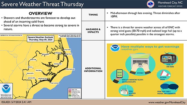
Please see below and attached briefing from the National Weather Service for more information.
From the National Weather Service, Morehead City:
There will be daily chances for shower and thunderstorm activity from today through Thursday. A few these storms have the potential to become severe with the greatest risk for seeing severe weather occurring on Thursday.
– For todays severe weather risk, greatest threat would be mainly along the sea breeze. Storm coverage would be isolated and timing would mainly fall between about 2PM-8PM. The strongest storms would bring the potential for strong wind gusts and hail.
– For Wednesday, another isolated strong to severe thunderstorm risk will be possible with threat timing once again falling between the afternoon to early evening. A risk for strong wind gusts and hail would be the primary hazard within the strongest storms
– For Thursday the greatest risk for severe weather occurs out ahead of an approaching cold front with timing focused from the mid afternoon into the evening. Once again a risk for strong wind gusts and hail would be the primary hazard within the strongest storms
NWS Morehead City -Severe Thunderstorm Risk May 9th – Breifing #1
More Weather


SportsPlus
How to Watch the MLB Baseball Playoffs on Sunday, Oct. 6: TV Channel, Live Streaming, Start Times
The San Diego Padres and the Los Angeles Dodgers take the field for one of many exciting matchups…
How to live stream NFL RedZone Week 5 with a free Fubo trial
Football fans, want to watch all of the NFL action this week? Forget flipping back and forth between…
MLB Playoff Betting Lines and Picks Today | Oct. 6
The San Diego Padres and the Los Angeles Dodgers hit the field in one of many exciting matchups…
How to Watch the WNBA Playoffs Today | Oct. 6
On a Sunday WNBA playoff slate that features two exciting matchups, the New York Liberty versus the Las…
WNBA Betting Picks: Sunday, Oct. 6
Wondering how you should bet on today’s WNBA games? Look no further. Below you’ll find computer predictions on…
-
Polls
 Loading ...
-
-