Severe weather update for Wednesday-Thursday
Published 2:38 pm Wednesday, May 8, 2024
|
Getting your Trinity Audio player ready...
|
From Chris Newkirk, Beaufort County Emergency Services:
Our office continues to monitor the forecast for the potential of severe weather this afternoon and tomorrow. Developing scattered storms will have the potential to intensify quickly, producing gusty winds (50 – 70mph), hail and isolated tornados. While these storms are possible both days, our greatest chance of experiencing severe weather conditions will be between 2pm and 8pm tomorrow.
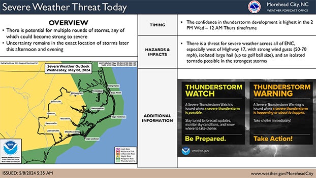
Please see below and attached briefing from the National Weather Service for additional details.
We encourage everyone to ensure that you, your family, friends and neighbors have a way of being notified of any watches and / or warnings that are issued for your area. (Weather alert phone apps that provide notifications, weather radios, etc.) We also encourage everyone to monitor local media outlets for additional updates.
From the National Weather Service, Morehead City:
There will be daily chances for shower and thunderstorm activity today through Friday. A few of these storms have the potential to become severe with the greatest risk for severe weather being on Thursday. However, there is still some uncertainty with exact timing and location of thunderstorm activity today and on Thursday as todays thunderstorm activity will have an impact on Thursday’s thunderstorm activity. But, both days have the potential to bring strong impacts to ENC.
– For todays severe weather risk, there is potential for multiple rounds of scattered strong to severe storms, there remains uncertainty of when and where thunderstorms will develop. Highest confidence in thunderstorm development is between 2 PM Wed – 12 AM Thurs, but the severe risk could last later into the night. A risk for strong wind gusts (50-70 mph), hail (up to golf ball size) and an isolated tornado or two will be the primary hazards within the strongest storms.
– For Thursday, the greatest risk for severe weather occurs out ahead of an approaching cold front with timing focused from the mid-afternoon into the evening. There is some uncertainty with exact timing of storms, as previous evenings convection could result in an earlier threat on Thursday. A risk for strong wind gusts (50-70 mph) and hail (up to quarter size) will be the primary hazards within the strongest storms.
NWS Morehead City -Severe Thunderstorm Risk May 8th-9th – Breifing #3
More Weather


SportsPlus
Buy Tickets for Carolina Hurricanes vs. Tampa Bay Lightning on October 11
The Carolina Hurricanes host the Tampa Bay Lightning on Friday, October 11 at 7:00 PM ET on ESPN+.…
How to Watch MLB Baseball on Saturday, Sept. 28: TV Channel, Live Streaming, Start Times
The New York Mets versus the Milwaukee Brewers is one of many solid options on today’s MLB slate.…
MLB Betting Lines and Picks Today | Sept. 28
Saturday’s MLB schedule has plenty of quality competition in store. Among those games is the New York Mets…
Best Bets, Odds for the Panthers vs. Bengals Game – Week 4
Check out best bets as the Cincinnati Bengals (0-3) will attempt to stop a three-game losing streak when…
Where to Watch East Carolina vs. UTSA on TV or Streaming Live – Sept. 28
On Saturday at 4:00 p.m. ET, the UTSA Roadrunners (2-2) will take on Jake Garcia and the East…
-
Polls
 Loading ...
-
-