Hurricane Idalia: Wednesday morning update
Published 10:49 am Wednesday, August 30, 2023
- (National Weather Service)
|
Getting your Trinity Audio player ready...
|
From Chris Newkirk, Beaufort County Emergency Services:
This morning’s update provided us with a few more details pertaining to the timing of our forecasted impacts. These changes have been highlighted below.
Rain
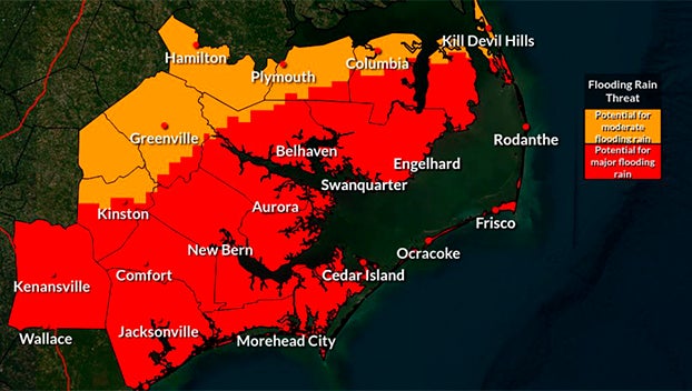
- Scattered rain will begin to move into our area around 4pm this afternoon with rain likely for all areas of our county by 11pm. A steady rain is expected to continue through 2pm Thursday with 4 to 6” of rain expected during this time. (Localized higher amounts are possible, especially for the southeastern portion of our county to include Blounts Creek, Edwards and Aurora.
- Our heaviest rains are expected to occur between 2am and 8am Thursday morning. These passing rain bands could be heavy at times, and capable of producing localized flash flooding.
- Rain should begin to exit our area by 8pm Thursday evening, with only scattered showers forecasted for Friday.
Winds
- A Tropical Storm Warning has now been issued for Beaufort County.
- Northeast winds will begin to increase after 2am Thursday morning, becoming sustained between 15 and 20 mph with frequent gust of 25 to 30 mph. These wind conditions will continue through 10am as Idalia approaches our area.
- NE winds will elevate once again around 10am as Idalia begins to pass to our south, becoming sustained between 20 and 25 mph with frequent gust of 30 to 40 mph. These wind conditions are expected to continue through 8pm Thursday afternoon.
- North and Northeast winds are expected to remain sustained between 10 and 20 mph with frequent gust of 20 to 25 mph through 5pm Friday.
Storm Surge
- A Storm Surge Watch has been issued for Beaufort County’s waterways. Our coastlines are now forecasted to receive 2 to 4 feet of storm surge between noon Thursday and late Friday morning.
- Areas that are vulnerable to long durations of North / Northeast winds such as the western shoreline of the Pungo River and southern shoreline of the Pamlico River should prepare for at least 4 feet of surge during this time.
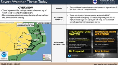
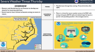
Severe Storms & Tornados
- As with many tropical weather systems, passing rain bands can result in severe thunderstorms capable of producing tornados. While severe storms are possible for all of Beaufort County Wednesday and Thursday, areas south and east of Belhaven, Bath and Blounts Creek will be at a slightly greater risk than other portions of our county.
Please see below and attached briefing from the National Weather Service for additional information.
From the National Weather Service, Morehead City:
Tropical Storm Warnings have been issued for Eastern NC with the latest forecast update. Please see the attached briefing for details on the impacts from Hurricane Idalia.
We remain in a prolonged period of dangerous rip current/surf conditions and beach erosion as Hurricane Franklin passes offshore and Idalia begins to impact the area. Localized Ocean over wash along the Outer Banks will continue during this time.
NWS Morehead City Briefing #8 Idalia
More Weather


-
Polls
 Loading ...
-
-