Tropical Storm Idalia: Thursday morning update
Published 10:19 am Thursday, August 31, 2023
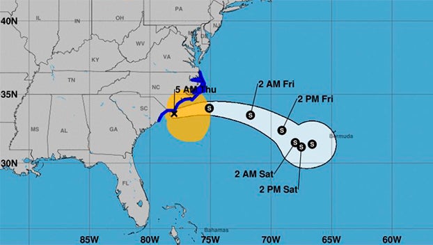
- (National Weather Service)
|
Getting your Trinity Audio player ready...
|
From Chris Newkirk, Beaufort County Emergency Services:
The current forecast continues to place Idalia further off of North Carolina’s coast at a slightly faster pace than previously expected, thus accelerating the arrival of improving conditions for our area. These changes have been highlighted below.
Rain
- Most of our county to include Washington, Chocowinity, Old Ford and Belhaven received 1 1/2 to 3 inches of rain overnight. Localized higher amounts of 4 to 5 inches are being reported in Pinetown and Aurora.
- The heaviest rains are now moving off shore. The light rain that we are currently receiving is expected to continue through 11am, before reducing to scattered showers and eventually ending around 6pm.
Winds
- Our current winds conditions (North sustained 15 to 25 with gust of 30 to 40) will continue through 6pm this afternoon.
- North wind sustained between 10 and 15 mph will continue through 5pm tomorrow. Frequent gust of 15 to 20 mph are possible between 9am and 5pm tomorrow.
Storm Surge
- Most of our shorelines are currently experiencing 2 to 3 feet of surge. These levels are expected to continue through the early afternoon and recede to near normal overnight.
Severe Storms & Tornados
- The tornado watch has been canceled for our area with no other threats of severe weather forecasted.
Please see below and attached briefing from the National Weather Service for additional information.
From the National Weather Service, Morehead City:
Flash Flood Warnings are in effect for portions of the southern coastal areas and Outer Banks. Heavy Rainfall will continue to be a significant threat this morning.
Gusty winds and dangerous marine conditions are ongoing and will continue through the day and coastal flooding remains a threat.
NWS Morehead City Briefing #10 Idalia
More Weather


SportsPlus
How to Watch MLB Baseball on Saturday, August 31: TV Channel, Live Streaming, Start Times
The Los Angeles Dodgers and the Arizona Diamondbacks square off in one of many compelling matchups on the…
How to Watch the WNBA Today | August 31
Today’s WNBA slate includes just one contest — the Connecticut Sun against the Washington Mystics. The WNBA is…
WNBA Betting Picks: Saturday, August 31
Wondering how you should bet on today’s WNBA game? Look no further. Below you’ll find computer predictions on…
Where to Watch East Carolina vs. Norfolk State on TV or Streaming Live – August 31
The Norfolk State Spartans (0-1) will visit the East Carolina Pirates on Saturday at 6:00 p.m. ET. We…
Washington Mystics vs. Connecticut Sun Betting Odds and Matchup Preview – Saturday, August 31
The Washington Mystics (9-22) will try to build on a three-game winning streak when hosting the Connecticut Sun…
-
Polls
 Loading ...
-
-