Hurricane Ian: Sept. 29 PM update
Published 6:44 pm Thursday, September 29, 2022
|
Getting your Trinity Audio player ready...
|
From Chris Newkirk, Beaufort County Emergency Services:
Please see below and attached briefing for the latest update from the NWS.
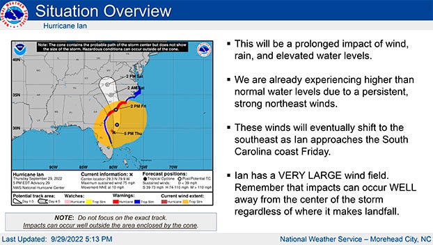
We are continuing to monitor subtle shifts in the forecasted track for Hurricane Ian, with some models now suggesting landfall along the central / northern coastline of South Carolina. (Georgetown and Myrtle Beach areas.) These variances bring with it the continuation of possible changes to the specific forecast for area as we go through the night. Changes as a result of this afternoon’s update have been highlighted below.
Rain
- 3 to 4” inches of rain is forecasted for our area. Our greatest chance of rain and highest hourly accumulation is currently forecasted to occur between 3am and 8pm Friday. Heavy downpours capable of causing localized flash flooding is possible during this time.
- Most of the rain should be exiting our area after midnight Friday, with only light rain expected after sunrise Saturday.
Winds
- Winds are currently forecasted to be sustained between 15 and 20 mph through midnight Friday, with frequent gust of 30 – 40 mph possible during this time.
Storm Surge
- A Coastal Flood Watch has been issued for Beaufort County. Persistently high NE winds will beginning transitioning to the east around sunset Friday, becoming SE by midnight and S by sunrise. These conditions are expected result in the following:
- 2 to 3 feet of inundation is expected along the coastal areas of the Pamlico River. (Areas near the back of Chocowinity Bay and west of Washington are expected to be on the higher side of this scale.)
- 1 to 3 feet is expected for areas along the Pungo River.
Note: These values and timelines may change with future updates.
We will continue to pass along information as we receive it.
NWS Newport/Morehead City:
No big changes with this update. The threats of heavy rain, strong winds, coastal flooding, and isolated tornadoes have not changed. The highest impacts for both heavy rain and the tornado threat will occur Friday. Please encourage people to have multiple ways to receive warnings Friday, if tornado warnings are issued.
We are already seeing some elevated water levels along the lower Neuse River and the southern part of the Pamlico Sound (Downeast Carteret). This will continue into Friday. Eventually winds will shift to the southeast by Friday afternoon, and new areas will be impacted by elevated water levels. The track has continued the trend of shifting east. While this has NOT changed our messaging now, if this continues, we may need to increase winds over the southwestern part of our forecast area.
NWS Morehead City Hurricane Ian Briefing #13 Sep 29th 2022
More Weather

-
Polls
 Loading ...
-
-