Flood Watch in effect through Thursday evening
Published 3:14 pm Tuesday, August 29, 2023
- (National Weather Service)
|
Getting your Trinity Audio player ready...
|
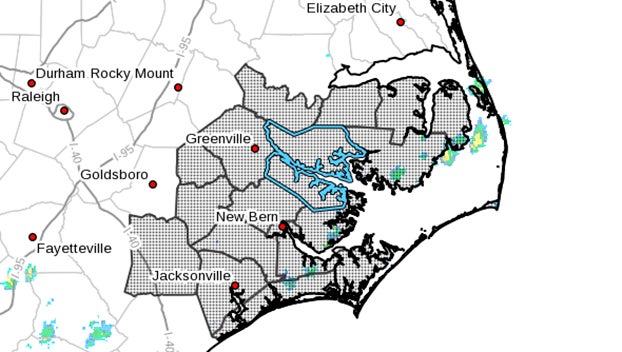
Martin-Pitt-Washington-Tyrrell-Mainland Dare-Greene-Beaufort-Mainland Hyde-Duplin-Lenoir-Jones-Pamlico-Northern Craven-Southern Craven-West Carteret-East Carteret-Inland Onslow-Coastal Onslow-Northern Outer Banks-Ocracoke Island-Hatteras Island-Including the cities of Atlantic Beach, Beulaville, La Grange, Robersonville, Plymouth, Stella, North Topsail Beach, Avon, Belhaven, Engelhard, Manteo, Stumpy Point, Trenton, Grimesland, Cove City, New Bern, Buxton, Columbia, Grifton, Kenansville, Fairfield Harbor, Southern Shores, Aurora, Oak City, Vanceboro, Jacksonville, Wallace, Faison, Greenville, Bethel, Hookerton, Dover, Oriental, Farmville, Manns Harbor, Vandemere, River Bend, Swansboro, Frisco, Harkers Island, Scranton, Maysville, Gum Neck, Walstonburg, Chocowinity, Bath, Fairfield, Bayboro, Havelock, Sneads Ferry, Warsaw, Kitty Hawk, East Lake, Morehead City, Cedar Island, Ernul, Emerald Isle, Pollocksville, Washington, Snow Hill, Swanquarter, Williamston, Kill Devil Hills, Duck, Ocracoke, Creswell, Half Moon, Rodanthe, Richlands, Hatteras Village, Sea Level, Nags Head, Roper, Beaufort, Ponzer, Arapahoe, Pink Hill, Newport, Jamesville, and Kinston
307 PM EDT Tue Aug 29 2023
…FLOOD WATCH IN EFFECT FROM WEDNESDAY AFTERNOON THROUGH THURSDAY EVENING…
* WHAT…Flash flooding caused by excessive rainfall is possible.
* WHERE…A portion of eastern North Carolina, including the following areas, Beaufort, Coastal Onslow, Duplin, East Carteret, Greene, Hatteras Island, Inland Onslow, Jones, Lenoir, Mainland Dare, Mainland Hyde, Martin, Northern Craven, Northern Outer Banks, Ocracoke Island, Pamlico, Pitt, Southern Craven, Tyrrell, Washington and West Carteret.
* WHEN…From Wednesday afternoon through Thursday evening.
* IMPACTS…Excessive runoff may result in flooding of rivers, creeks, streams, and other low-lying and flood-prone locations.
* ADDITIONAL DETAILS…
– Tropical Cyclone Idalia will bring heavy rain across Eastern North Carolina. Rainfall amounts between 2 to 6 inches, with isolated amounts of up to 8 inches possible.
– http://www.weather.gov/safety/flood
PRECAUTIONARY/PREPAREDNESS ACTIONS…
You should monitor later forecasts and be prepared to take action should Flash Flood Warnings be issued.
Motorists should not attempt to drive around barricades or drive cars through flooded areas.
More Weather

-
Polls
 Loading ...
-
-