Weekend weather impact: Thursday afternoon update
Published 3:14 pm Thursday, September 21, 2023
- (National Weather Service)
|
Getting your Trinity Audio player ready...
|
From Chris Newkirk, Beaufort County Emergency Services:
The noon update from the National Weather Service has provided us with additional information regarding this weekend’s potential weather impacts. First, this system is just beginning to get organized in its formation, and therefore will rapidly change over the next 24 hrs. During this time, you may hear a lot of discussion as to whether or not it remains a subtropical system, becomes a tropical depression or even a named Tropical Storm as Ophelia. Regardless of whether it becomes a named system or not, our forecast partners are confident this system will bring the following rain, wind and storm surge impacts to Beaufort County. (Changes from last night’s update have been highlighted.)
Rain
- Rain will begin to move into the area around 8am Friday morning and continue through 1am Sunday. 2 to 3 inches of rain is expected for areas west of Bath and Blounts Creek during this time, with areas west receiving 3 to 4 inches.
- Our greatest chance of rain is currently forecasted to occur between 2pm Friday and 1pm Saturday.
- Our heaviest rains are expected to occur between 2pm and 8pm Friday.
Winds
- North and Northeast winds will begin to increase around 4am Friday morning becoming sustained between 20 and 25 mph with frequent gust of 25 to 30 mph by 4pm. These wind conditions are expected to continue 10am Saturday morning.
- Winds will begin to transition to the West after 10am Saturday and remain sustain between 15 and 20 mph with frequent gust of 20 to 30 mph through 1am Sunday morning.
- Areas that are adjacent to our county’s shorelines and vast open farm land will experience higher sustained winds and gust. (25 to 30 sustained with gust of 30 to 40 mph.)
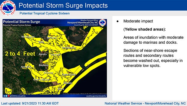
Storm Surge
Our waterways are currently forecasted to receive 2 to 4 feet of storm surge Friday and early Saturday morning. However, these values will be extremely dependent upon the exact track of the storm. For example, the current track indicates that the center of the storm will make landfall near Cape Lookout, which would keep the stronger Northeast winds to our east. However, if the center track shifts to the west, with landfall occurring around Pender or Onslow Counties, then our surge values could increase to 3 to 5 feet. So far, there have been no indications that our surge will exceed 5 feet.
Please see below and attached briefing from the National Weather Service for additional information. We hope to release our next update by 7:30pm. In the meantime, we encourage everyone to monitor your local media outlets for additional information.
*For anyone planning to attend ECU’s home opener in Greenville on Saturday, the current game time forecast is as follows:
- Rain chances will begin to diminish around 2pm, with 3 to 4 tenths of an inch expected between 2pm and 10pm.
- Sustained west winds between 15 and 20 mph with gust of 20 to 25 mph are expected between 2pm and 10pm.*
From the National Weather Service, Morehead City:
Attached is our first full briefing on Potential Tropical Cyclone Sixteen. A tropical storm warning has been issued for a good portion of our area, along with Storm Surge Watches along the inland rivers and sounds, and our entire coast. Our biggest concerns are potential for storm surge, strong winds (especially near the coast and over the waters) and localized heavy rain. Refer to www.weather.gov/gov/tropical for more information.
NWS Morehead City Briefing #3 Potential Tropical Cyclone Sixteen
More Weather

-
Polls
 Loading ...
-
-