Potential for inclement weather this weekend
Published 5:37 pm Thursday, December 14, 2023
|
Getting your Trinity Audio player ready...
|
From Chris Newkirk / Beaufort County Emergency Services:
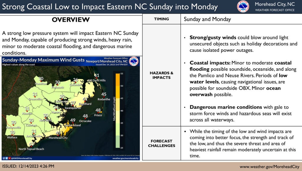
This afternoon’s update continues to trend towards a strengthening storm system for our area Sunday and Monday. Changes in the latest forecast includes an increase in expected sustained winds and wind gust. (Gust were elevated from 25 mph to 30+.) These changes haves been highlighted in the forecast below. As previously mentioned, this continues to be a very dynamic weather system with additional changes to our forecast expected.
Current Forecast for Beaufort County
Rain
- Rain chances will increase after sunrise Sunday and continue through noon on Monday, with most areas currently forecasted to receive 2 to 3 inches.
- Our heaviest rains are currently expected to occur between 1pm Sunday afternoon and 8am Monday morning.
Winds
- Our forecasted winds will transition through various intensities and direction as follows:
- Sunday 8a – 4pm: East winds sustained between 10 and 15 mph with frequent gust of 20 to 25 mph.
- Sunday 5pm – 9pm: SE winds sustained between 15 and 20 mph with frequent gust of 25 to 30 mph.
- Sunday 10pm – Monday 7am: South winds between 15 and 20 mph with frequent gust of 25 to 30 mph.
- Monday 8am – 2pm: SW winds sustained between 15 and 20 mph with frequent gust of 20 to 35 mph.
- Monday 3pm –Tuesday 2am: W winds sustained between 15 and 20 mph with frequent gust of 20 to 30 mph.
- Tuesday 3am – Wednesday 8am: NW winds sustained between 10 and 15 mph with frequent gust of 20 to 25 mph.
Flooding
- Heavy rains along with elevated South and SE winds that will push water up the Pamlico River are expected to create a potential flooding hazard for shoreline and low-lying areas on Sunday. While surge amounts have yet to be included in the forecast, our office would not be surprised to see references of inundation levels ranging between 2 and 4 feet above normally dry ground in future updates. This expectation is based on the wind direction and intensity forecasted for Sunday. If these forecasted conditions remain true, we anticipate the levels along our waterways to quickly rise after 8am Sunday morning and continue through the daylight hours. That increased water level would most likely remain through midnight Sunday before subsiding early Monday morning.
What To Watch For
- We encourage everyone to continue to monitor the following potentials for this weekend’s forecast.
- Continued Increasing Wind Gust Values – Forecast trends continue to suggest that wind gust values for our area could continue to increase in future updates.
- Surge / Inundation Values – Again, the forecasted winds conditions will impact the levels along our waterways. We anticipate having details pertaining to this level in future forecast updates from the National Weather Service.
Please see below and attached briefing from the National Weather Service (NWS) for additional information. Our office will continue to pass along updates we receive them.
From National Weather Service, Newport/Morehead City:
A strong low is forecast to impact eastern NC Sunday into Monday. There is an increased likelihood for several impacts from this system including localized flooding, gusty winds, dangerous marine conditions, and coastal impacts.
Please see the attached briefing for the latest information:
NWS Morehead City Multiple Hazards Two Pager #1 – Dec 14, 2023
More Weather

-
Polls
 Loading ...
-
-