Severe weather update: Sunday morning
Published 8:59 am Sunday, December 17, 2023
|
Getting your Trinity Audio player ready...
|
From Chris Newkirk, Beaufort County Emergency Services:
Changes in this morning’s update included another increase in potential rainfall and minor changes to the overall timing of forecasted impacts. These changes have been highlighted in the detailed forecast below.
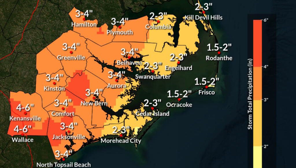
Rain
- Rain chances will increase after sunrise Sunday and continue through sunrise Monday, with most areas currently forecasted to receive 3 to 4 inches.
- Localized amounts of up to 6” are possible along and west of Hwy 17.
- Our heaviest rains are currently expected to occur between 1pm Sunday and 1am Monday.
Winds
- Sunday
- Winds are forecasted to be sustained between 15 and 30 mph on Sunday with frequent gusts ranging from 30 to 40 mph for inland locations and 40+ mph possible for shoreline and open agricultural areas. (This will be especially true for waterfront communities near Hickory Point, Bayview, Pamlico Beach, & Belhaven)
- Our highest winds are forecasted to occur between 4pm and 10pm Sunday.
- Monday
- Winds are forecasted to be sustained between 10 and 20 mph with frequent gust ranging from 20 to 30 mph. Again, slightly higher gust is possible for shoreline and open agricultural areas.
- These forecasted winds will transition through various intensities and direction as follows:
- 8a – 5pm Sunday: East winds sustained between 10 and 20 mph with frequent gust of 20 to 30 mph.
- 6pm – 10pm Sunday: SE winds sustained between 15 and 30 mph with frequent gust of 25 to 40 mph.
- 11pm Sunday – 2 am Monday: South & SW winds between 10 and 25 mph with frequent gust of 15 to 35 mph.
- 3am – 5pm Monday: West winds sustained between 15 and 20 mph with frequent gust of 20 to 30 mph.
Flooding
- A Coastal Flood Warning has been issued for Beaufort County, meaning that moderate to major coastal flooding is imminent for our county’s waterfront areas.
- Our county’s shorelines are forecasted to receive 3 to 6 feet of inundation above normally dry ground Sunday and Monday morning..
- Given the current forecast, we anticipate the water levels to quickly rise between 8am and 8pm Sunday as we endure strong east and southeast winds. The rate of rise is expected to slow and / or remain relatively stable as we experience south winds between 9pm Sunday night and 2am Monday. Water levels should begin to subside quickly with west winds after 3am Monday morning.
- We encourage anyone that was significantly impacted by flooding from Ophelia last September to take this weekend’s flood threats seriously.
Thing To Consider And Watch For
- While the science of forecasting weather has and continues to improve by leaps and bounds, we are not given the benefit of having a 100% accurate crystal ball, and the weather stills retains the ability to be unpredictable at times. Therefore, it is important to give consideration to trends. Over the last 3 days, the forecast has consistently trended towards increasing winds and hazardous flooding threats. Please continue to monitor these conditions and prepare accordingly.
Safety & Preparation Reminders
- Due to the forecasted timing, impacts and dynamic nature of the storm, we encourage residents to limit travel for non-essential purposes from Sunday morning to Monday morning.
- Prepare your emergency supply kit. This should include a food and water supply, medicines, emergency power sources, safety and personal items, and important documents.
- Have arrangements for temporary housing in place in case you need to evacuate your residence during the storm. Have an emergency contact outside of the impacted region who can help you as needed.
- If you have a boat and plan on leaving it in the water during the storm, make sure it stays properly secured by making anchoring/mooring arrangements and removing valuable equipment from the boat.
- Make sure you have multiple ways of receiving emergency updates. Check your radio, local TV stations, cell phone and similar devices for updates on the storm. Make sure you have chargers and extra batteries available for your devices.
- If you have a generator, verify it is functioning before the storm arrives. Never run a portable generator inside your home.
- Do not attempt to drive on flooded roads.
Please see below and attached briefing from the NWS for more information.
This will be the last scheduled update from the National Weather Service. We encourage everyone to monitor local media outlets for any additional watches and / or warnings that may be issued. Local updates can also be found on the following:
- Beaufort County Emergency Services
- Beaufort County Sheriff’s Office
- Facebook: https://www.facebook.com/BeaufortCountySheriffNC
- Android & iPhone App: Check out the Beaufort County Sheriff NC mobile app at: https://apps.myocv.com/share/a101327889
- National Weather Service
- Facebook: https://www.facebook.com/NWSMoreheadCity
From National Weather Service, Morehead City:
Our primary changes this morning:
- Issuance of a Flood Watch for much of Eastern NC
- No major changes were made to the forecast overall
NWS Morehead City – Hazards Briefing #7 – Strong Low Dec 17 and 18
More Weather

-
Polls
 Loading ...
-
-