NWS issues coastal flood advisory, hazardous weather outlook for Saturday
Published 12:22 pm Friday, March 22, 2024
- (National Weather Service)
|
Getting your Trinity Audio player ready...
|
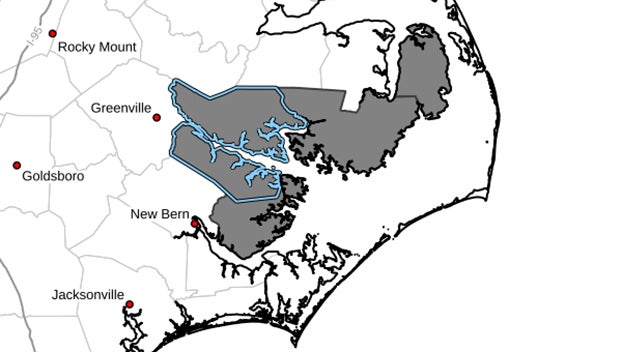
Coastal Flood Advisory
Coastal Hazard Message National Weather Service Newport/Morehead City NC 921 AM EDT Fri Mar 22 2024 NCZ047-080-081-094-230130- /O.NEW.KMHX.CF.Y.0012.240323T0900Z-240323T2200Z/ Mainland Dare-Beaufort-Mainland Hyde-Pamlico- 921 AM EDT Fri Mar 22 2024 ...COASTAL FLOOD ADVISORY IN EFFECT FROM 5 AM TO 6 PM EDT SATURDAY... * WHAT...1 to 2 feet of inundation above ground level expected in low-lying areas near shorelines and tidal waterways.. * WHERE...Areas along the Pamlico Sound, Pamlico and Pungo Rivers, and adjacent tidal creeks. * WHEN...From 5 AM to 6 PM EDT Saturday. * IMPACTS...Flooding of lots, parks, and roads with only isolated road closures expected. PRECAUTIONARY/PREPAREDNESS ACTIONS... If travel is required, allow extra time as some roads may be closed. Do not drive around barricades or through water of unknown depth. Take the necessary actions to protect flood-prone property.
Hazardous Weather Outlook
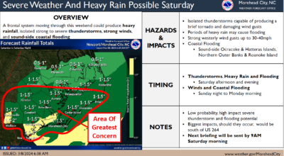
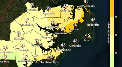
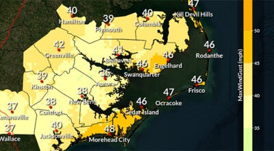
Hazardous Weather Outlook National Weather Service Newport/Morehead City NC 953 AM EDT Fri Mar 22 2024 NCZ047-080-081-094-231400- Mainland Dare-Beaufort-Mainland Hyde-Pamlico- 953 AM EDT Fri Mar 22 2024 ...COASTAL FLOOD ADVISORY IN EFFECT FROM 5 AM TO 6 PM EDT SATURDAY... This Hazardous Weather Outlook is for eastern North Carolina. .DAY ONE...This afternoon and tonight. Widespread rainfall with periods of heavy rain tonight may lead to localized flooding. There is also a possibility for strong to severe thunderstorms developing which could lead to damaging winds gusts. .DAYS TWO THROUGH SEVEN...Saturday through Thursday. Please listen to NOAA Weather Radio or go to weather.gov on the Internet for more information about the following hazards. Coastal Flood Advisory. Widespread rainfall with periods of heavy rain Saturday may lead to localized flooding. There is also a possibility for strong to severe thunderstorms developing which could lead to damaging winds gusts. Winds gusting to 30 to 35 mph possible Saturday morning into Sunday. .SPOTTER INFORMATION STATEMENT... Spotter activation is not expected at this time.
More Weather

-
Polls
 Loading ...
-
-